Showing posts with label Ladakh. Show all posts

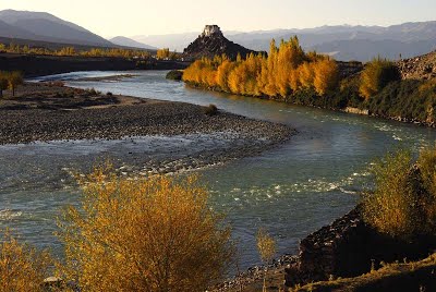
Likir to Temisgam | The Sham Trek in Ladakh

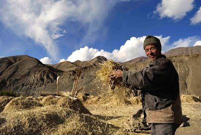
Harvesting mustard in Hemis Shukpachen
INTRODUCTION
You won’t find an easier trek than this in Ladakh. The passes are all below 4,000m, and the distances between places are relatively short. Plus, there is the added bonus of the Himalayan Homestays offering accommodation in village homes, which means you don’t have to lug tents and equipment all the way.


The Sham area of Ladakh is quite dry and hot and although you can trek this route anytime from the beginning to end of Ladakh’s tourist season (late May-late September), When I trekked this route around ten years ago , the link road from Likir to Temisgam was just being built. Today, it is a full-fledged ‘pucca’ road, albeit with little traffic. So much of the journey can be done comfortably following the road all the way.

ROUTE
DAY 1 LIKIR-PHOBE LA-CHAGATSE LA-YANGTHANG
DISTANCE 9 KM TIME 4-5 HOURS LEVEL MODERATE


Young lamas at morning prayers at school in Likir Monastery
 We will drive in the morning to Likir from Leh ( 90 min). After visiting  the Likir monastery we will start our trek. Although the distance today is short, the route is hot, without any shade or water and you must traverse two passes, so start early with water bottles filled. For Ladakh, these passes are low, but do not underestimate them. From Likir,, take the road heading west up to Phoebe La (3,580m). The climb is gentle and you will top the pass in an hour. From the pass, you can scramble down the short-cut tracks and meet up with the road below, avoiding the longer loops of the jeep road.
 The road continues west to Sumdo, a small settlement where you can stop for tea. Just before Sumdo, you will need to cross the stream over a bridge. From Sumdo, follow the main road that climbs steadily upwards, winding its way to the west for a little over an hour. From Chagatse La it is another 30 mins down. The village of Yangthang (3,630m) is on your left through the fields.. If you reach early and have the energy, check out the Ridzong Monastery, which lies about an hour south of Yangthang. This quiet, secluded gompa is over a hundred years old and nestles in a narrow gorge.

DAY 2 YANGTHANG-TSERMANGCHEN LA-HEMIS SHUKPACHEN 
DISTANCE 8 KM TIME 3-4 HOURS LEVEL EASY


Descending from the pass of Tsermangchen La
 Today is an easy walk despite the pass because both the approach and the descent are of gentle gradients. From Yangthang Village, head back through the fields onto the road that brought you here and turn left, or west. The road heads north, descending for a bit, crossing a stream before climbing up west again to Tsermangchen La (3,750m). Take a break at the pass before heading down to Hemis Shukpachen. The village, named after the grove of cedars (shukpa in Ladakhi) is one of Ladakh’s prettiest. There are plenty of sparkling streams surrounded by shady willows and large barley fields that add the much needed dash of green to the otherwise desolate, rocky mountains. 


Day 3 HEMIS SHUKPACHEN TO LEH


Chortens and statues at Hemis Shukpachen
The car from Leh will come around 11 am to pick us up and we will be back in Leh by lunch time.

For more photos of Ladakh and Zanskar do visit  http://www.sujoydas.com/Ladakh-and-Zanskar

For our treks in Ladakh in 2017 do visit http://www.southcol.com/treks-nepal/rumtse-to-tso-moriri/


Ladakh | After Dusk

Campsite on the first day of the Phyang to Hundar trek

Over the past few years in Ladakh,   I have been shooting a number of locations after dusk mostly using my tripod and sometimes with long time exposure. This post showcases some of the "after dusk" images.

Star trails over Mount Kangyatse

The Stok Kangri range and Leh town at dusk

Moonlight at Hanker on the Markha valley trek

Lamayuru monastery

The tea tents and campsite of Nimaling

For more photographs from Ladakh and Zanskar do visit

For our 2017 trek in Ladakh do visit

Ladakh Flora II

Many people assume that since Ladakh is a barren cold desert nothing grows there. However, if you do visit Ladakh during the summer months and trek in the mountains you will be greeted with a  variety of wild flowers of different colours and textures. This is the second post in the series of Ladakh flora. The first post can  be found at  http://sujoyrdas.blogspot.in/2016/08/ladakh-flora-i.html


For more posts from Ladakh do visit  http://sujoyrdas.blogspot.in/search/label/Ladakh

For photographs of Ladakh and Zanskar do visit  http://www.sujoydas.com/Ladakh-and-Zanskar

For treks in Ladakh do visit  http://www.southcol.com/treks-nepal/rumtse-to-tso-moriri/

Ladakh Flora I

Most people who have not been to Ladakh imagine it to be a barren wasteland devoid of vegetation and flowers. But in the summer months many of our Himalayan floral species bloom in this high altitude desert.  Some of the flora of Ladakh seen over different treks and expeditions mainly between the months of July to September are below in this two part post. The second part will follow soon.


Markha Valley Trek | Ladakh July 2016 - Route and Timings

Campsite at Markha below the monastery

South Col Expeditions trekked the Markha Valley from Chilling to Shang Sumdo in July 2016. The day wise route and timings along with altitude  is given below.

July 17th 2016 Leh to Chilling to Skiu
We left Leh around 8 am. The previous day it had been drizzling the whole day and this had helped in bringing down the temperatures. Leh had been very warm  for the last few days and the rain was most welcome. We followed the Leh Kargil highway to Nimu   which is the confluence of the Indus and the Zanskar.  After some photographs at the site we went down on the road to Chilling which is 28km away. The road contours along the Zanskar river and we reached Chilling by 9 45 am. The bridge across the Zanskar is broken so we had to cross once again by trolley. By the time we had all our equipment and team across it was 11 am. We started walking east and in about 45 minutes crested a small pass which was visible from the river. There is a new jeepable road between Chilling and Skui and we followed this for most of the way excepting using some short cuts which avoided the long bends of the road. In about an hour from the first pass we reached the entrance of the village of Kaya and walked further up through the village until we reached the river where we stopped for lunch around 1 30 pm. The sun was hot but clouds were gathering towards the west. We left our lunch spot around 2 pm and in another 45 minutes reached the campsites of Skui. Skui also has a number of home stays so it is now possible to do the Markha valley trek in season time without camping support. The camp was the same location as last time pitched near the river. As it was both sunny and warm I decided to go down to river and have a wash in the delicious cold water which was incredibly refreshing. The next day we have a long walk to Markha around 22 km.
Chilling to 1st pass 45 min; 1st pass to Kaya village 1 hour; Kaya village to Skiu campsites 1 hour
Leh 3500 metres 34 10 11 N 77 34 40E; Chilling 3183 metres 34 0 31 N 77 12 24E;
Skiu 3348 metres 33 58 44 N 77 16 18E
Chilling to Skiu 9.8 km  approx.

July 18 2016 Skiu to Markha
We left Skiu at around 7 25 am. We initially followed the jeepable road and in about 90 minutes reached the tea stop of Pendse. From here in about half an hour we found that the river had overrun the entire road and crossing was difficult without  getting into the water. Another French trekker who had crossed with difficulty helped our group by bringing big boulders and throwing them into the water to make a path. This crossing delayed us for around half an hour and we started off again around 10 am. By around 11 30 am we reached a tea tent which was Humarge and then set out for Sera village which was the lunch stop. Around noon a  rain shower with high winds hit us and descending to Sera we got totally soaked. Around 12 40 pm we entered the first tea tent of Sera and had our lunch along with some hot tea made by the owner. We left Sera around 1 10 pm and headed up the valley. The trail climbed in parts and around 2 30 pm passed a very pretty village with mustard fields in  bloom. From the village a climb of around 30 minutes brought us to some chortens on a ridge. The path then went down to the river bed and again climbed up to another small pass around 4 pm with chortens in three colours. At the end of this valley lay the camping grounds of Markha which we finally reached around 5 pm after wading through the fast flowing Markha river which had knee deep water.  It had been a long and tiring day and the most which we would walk during this trek.
Skiu to Pendse Tea Shop 1 hr 45 min to 2 hours; Pendse to Sera village 2 to 2.5 hours;  Sera village to chortens above Markha 2 to 2.5 hours; Chortens above Markha to camp ground 45 min to 1 hr
Markha 3760 metres 33 53 14 N 77 25 18E
Skiu to Markha 22.5 km.

July 19 2016 Markha to Hanker
We left Markha around 8 am and headed up for the monastery. The monastery has a beautiful view of the Markha valley. All the fields below were yellow and green with mustard flowers in full bloom. We descended to the valley and started walking due east following the river. In about 45 minutes we had to cross the river once again by wading across the water. The July rains for the past few days had caused the rivers to swell and walking across was no more a possibility. It had become very hot in the valley and in about an hour from our river crossing we reached  the  tea tents of Umlung. From Umlung the trail initially followed the river valley and then contoured around some mani walls and chortens from where finally Hanker could be seen. The final walk to the village took around an hour as there were sections which had to be carefully navigated near the river where the path was nonexistent and a slight lapse of concentration would send you into the water.
Markha to the river crossing 45 min to 1 hour; River Crossing to Umlung tea tents 45 min to 1 hour; Umlung to Mani wall above Hanker 1 hour; Mani wall above Hanker to Hanker Village 1 hour.
Hanker 3945 metres 33 50 13 N 77 30 6 E
Markha to Hanker 11 km

July 20 2016 Hanker to Lake Camp below Kangyatse
We left Hanker around 7 40 am and climbed out of the valley to immediately reach a line of chortens. The trail then contoured through cultivated fields of barley and mustard following the river. In about an hour it left the river and climbed up to a trail which crossed over a bridge and reached the tea tents of Taughutse in around two hours. From Taughutse the trail climbed out of the valley and continued upwards for around  two hours until it reached a small pass at around 4650 metres. It then passed a couple of mani walls to reach a small lake below Kangyatse peak. In July when we arrived there was a second lake below the first lake on the trail to Nimaling - this would probably dry out by September once the water in the Markha river goes down.
Hanker to Taughutse tea tents 2 hours; Taughutse to Lake Camp 2.5 to 3 hrs
Lake Camp  4660 metres 33 48 19 N 77 33 32 E
Hanker to Lake Camp 12 km

July 21 2016 Lake  Camp to Nimaling via the top route
The Lake Camp where South Col Expeditions makes a night stop on the Markha trek is not a regular stop for other groups. The reason is that it is hardly two hours from Nimaling, the base for crossing the Kongmaru La  around 5150 metres. However the location of the lake just below the peak of Kang Yatse makes this a superb campsite possibly the best on the entire trek. On this visit rather than do the conventional two hour walk along the valley to Nimaling I decided to climb another 300 metres or so to the grazing pastures below Kangyatse and then descend to Nimaling bypassing the valley route. We started late around 8 45 am and followed the trail from the lake due south towards Kangyatse. The trail then veered to the east and some cairns could be seen on top of a hill. We climbed to the top in around an hour. The meadows were simply  splendid  - yaks grazed on the lush green vegetation,  the ladakh pika or mouse hate scurried in and out of its burrow searching for food, overhead two lammergeiers soared with the thermals while a multitude of finches, redstarts and thrushes skimmed through the lush vegetation. On would imagine Ladakh to be arid and dry but not these meadows in summer above Nimaling. We came to a stream which ran below Kangyatse  and followed it gently upstream. Our altitude showed 4940 metres, almost 300 metres higher than Lake Camp. Across the valley we could see quite clearly the trail to the Kongmaru La. It was a sparkling July day with the temperatures around a comfortable 20 Celsius. A light wind blowing across the meadows helped to cool things down. We then walked in a north easterly direction towards Nimaling and started to descend from the pastures. In about half an hour we could see the tea tents of Nimaling below us and in another half hour we reached our camp site. For those of you who have some time and are on a camping trek, the Lake camp and the high route to Nimaling is greatly recommended.
Lake Camp to Nimaling via the high route 3 to 4 hours. However, there are no well trodden trails you need to follow the yak trails and navigate using the compass.
Nimaling 4731 metres 33 47 25 N  77 37 2 E
The distance we walked was around 7 km and we reached upto 4940 metres.

July 22nd 2016 Nimaling to Kongmaru la and down to Chukirmo
We left Nimaling around 6.45am. It was a cloudy morning and Kangyatse was floating above the clouds. We climbed steadily and in about an hour reached a meadow where a large number of Ladakh pika were scurrying in and out of their burrows. From here we could see the steep climb upto the top of the pass. In the meadows at an altitude of around 5000 metres there were some beautiful blue flowers flowering in the rocks. We reached the top of Kongmaru la around 9 30 am after numerous stops. The view to the north which is normally very expansive was under clouds and as we stood there a few flakes of snow started to fall. The descent from Kongmaru la was steep and for the first hour zigzagged around the hillside losing around 300 metres. It then entered the gorge of the river valley where the trail had been damaged due to floods. There were numerous ups and downs - climbing out of the river bed and onto the trail above the rocks and then down to the river bed again to avoid the landslide sections. This continued for about three  hours before the trail suddenly narrowed and we could see the tea tents of Chukirmo.
Nimaling to Kongmaru La  3 km  Kongmaru La to Chukirmo  8 km
Nimaling to Kongmaru La  2 to 3 hours
Kongmaru La to Chukirmo  4 to 5 hours
Kongmaru La  5250 metres 33 47 25 N 77 37 2 E
Chukirmo 4100 metres 33 49 29 N 77 39 7 E

July 23rd 2016 Chukirmo to Shang Sumdo to Leh
We left Chukirmo around 7.30 am and leaving the camp site had to come down to the river and follow the river bed once again. In half an hour we reached the village of Chogdo which had some nice homestays and some green camp grounds above the river which would be much nicer than Chukirmo. Stanzin mentioned that there could be a problem with water if we had used these camp spots.  The trail then continued down the valley for around two hours and we entered Shang Sumdo around 9.45 am. Our transport had come and we trundled back to Leh after paying the Hemis National Park fees. We were back in Leh by lunchtime looking forward to a hot bath and clean clothes.
Chukirmo to Chogdo 30 min to 45 min
Chogdo to Shang Sumdo  2 hours to 2.5 hours
Chukirmo to Shang Sumdo distance  13 km
Shang Sumdo 3550 metres 33 85 71 N  77 70 44E 

For  our earlier posts on the Markha do visit 
http://sujoyrdas.blogspot.in/2014/02/the-markha-valley-trek-part-i.html
http://sujoyrdas.blogspot.in/2014/03/the-markha-valley-trek-part-ii.html
http://sujoyrdas.blogspot.in/2014/03/the-markha-valley-trek-part-iii.html

Markha Valley | Hindu Business Line Blink April 30th 2016

feature Image

The Markha Valley is one of the most popular treks in Ladakh. It is relatively short, located close to Leh, the walking is mostly below 4000 metres with  night stops around 3500 metres and has the best of Ladakh thrown in: Sculpted canyons and fantastic rock formations, medieval villages,  Buddhist gompas and snow-peaks. When approached from Chilling there is only one pass to cross the Kongamaru La which comes on Day 8 of the trek by which time most trekkers are properly acclimatised.  The photos below give a description of the trek which I wrote for Hindu Business Line Blink for the April 30th 2016 issue.

To read the article on line please visit http://www.thehindubusinessline.com/blink/cover/a-himalayan-trek-is-always-a-rewarding-escape-from-the-scorching-plains/article8532688.ece


To trek the Markha with us from July 15th to 24th 2016 do visit this link for all information  http://www.southcol.com/treks-nepal/the-markha-valley-trek/


Click on the photo to enlarge

Click on the photo to enlarge

Markha Valley Trek | Ladakh | July 15th to 24th 2016


South Col Expeditions will once again be trekking the beautiful Markha Valley in Ladakh from July 15th to 24th 2016. The details and schedule of the trek is below:

Day 01 Delhi to Leh  
We take the  spectacular one hour flight over the Himalayas to Leh. Be prepared to sit on the left hand window seat for the best views. The rest of the day is spent acclimatizing in Leh.
Day 02 Acclimatization day in and around Leh
We take the opportunity to visit some of the splendid monasteries in and around Leh like Shey, Thikse, Hemis etc.
Day 03 Leh to Chilling by road and then walk to Skiu 3400m (4 hours)
We leave Leh in the morning after an early breakfast and then drive to Chilling in around  two and a half hours. We meet our pony man and support team in Chilling.  From Chilling we start our four hour walk to Skiu  and reach by later afternoon.
698212474__dsc0094
Day 04   Skiu to Tunespa 3600 m ( 4 hours)  
The trail is mostly flat following the Markha river. After around three hours the trail crosses a bridge and then traverses some steep slopes before entering the hamlet of Chaluk. From Chaluk there is a short walk to Tunespa which is small village with cultivated fields. 
 Day 05 Tunespa to Markha 3700 meters 3 hours and then Markha to Hankar 3900 metres 3 hours 
The trail from Tunespa climbs up to some chortens from where there is a good view of the valley. It continues to follow the river until it enters Markha where we have lunch. From Markha it is a gentle climb past Umlung to Hankar where we stop for the night.
Day 06  Hankar to Tahungtse 4150 metres 3 hours   and the  Tahungtse to the Tea Tent (lake) 3 hoursFrom Hankar the trail climbs to reach the walled pastures of Tahungtse. We stop for an early lunch here and then proceed after lunch to reach the small tarn with excellent mountain views. There is a small tea tent here in season for refreshments

 Day 07   Tea Tent to Nimaling ( 4720 meters) 2 hours uphill  
The  trail climbs to Nimaling which is a large valley where yaks, sheep and goats are grazed by the villagers of Markha. We do a short day to Nimaling as the next day has a pass crossing and a stiff downhill! It is beautiful campsite but can often be cold and windy!

Day 08 Nimaling to Kongmaru La 5100 meters 2 hours and then down to Chukirmo 4050 meters four hours
The trail then climbs to the pass of Kongmaru La from where there are good views over the Zanskar mountains and the peak of Kang Yaze. From the pass the trail drops steeply for about 1000 metres to the settlement of Chukirmo where we camp for the night.
520365407__dsc0030
Day 09  Chukirmo to Shang Sumdo 31/2 hours and then drive to Leh two hours
The trail continues to drop but more gradually now to  Chogdo and then passes a school and finally enters Shang Sumdo. We have our packed lunch in Shang Sumdo and then drive  back to Leh.
Day 10   Leh to Delhi
We can avail the morning flight from Leh to Delhi and be back in civilization in an hour!  In case you wish to stay on in Leh further please do inform us for hotel bookings and onward reservations.
For a detailed pdf of this trek please email sujoyrdas@gmail.com.

Phyang to Hundar Trek | Videos


Snowfield below Lasermo La pass
South Col Expeditions trekked the unspoilt route from Phyang to Hundar in September 2015. Here are some videos from the trek covering the view from Lasermo La and the crossing of a stream near Nuru Dok on the first day's walk.


For more information on this trek do visit:

Part I
http://sujoyrdas.blogspot.in/2015/11/from-indus-to-nubra-valley-across.html

Part II
http://www.sujoyrdas.blogspot.in/2015/11/from-indus-to-nubra-valley-across_23.html


From the Indus to the Nubra Valley across Lasermo La - Part II


The top of the pass Lasermo La
Phyang to Hundar Trek Part II

A South Col team trekked from Phyang to Hundar in September 2015. The detailed trek notes for the first part of the trek was covered in my blog post last week in this link http://sujoyrdas.blogspot.in/2015/11/from-indus-to-nubra-valley-across.html
The his is the second and concluding part.

September 5th 2015
We had planned to start at 6 am for the pass but when I woke up at around 4 am it was snowing lightly. The sky was also very misty with the clouds scudding across the moon. We finally left around 7 15 am when the snow had eased off and the sun was coming through the clouds.


 The trail as usual was difficult to find and there was some scrambling across boulders until we found a path of sorts which followed the valley to the bottom of the pass which we reached around 11 am. We passed some splendid blue flowers amidst the crags nestling below the snow.


From the bottom the trail climbed steeply to the first ridge in about half an hour and then climbed through a series of zig zags reaching the top of the pass around 12 15 pm.  I had brought a prayer flag which we tied across the pass and then along with Pema and Passang  two of our support team we built a small cairn in memory of my mother in law who had passed away a few months before – It was a  high and remote spot;  a stairway to heaven.


The rest of our group arrived in dribs and drabs the last member reaching at around 2 pm. We took the group photos and then headed down across a glacier which took us about 45 minutes to traverse.  From the glacier the path descended onto rocks and again navigating the way became very difficult. The descent seemed never ending and finally we reached the north base camp of Lasermo around 5 pm in the evening. Our last member came in at around 6 45 pm just as the light was fading from the sky. It had been a long and difficult day.


Lasermo La Pass 5474m - 34 18 24 N - 77 29 9 E. Lasermo La North Base Camp 4968m - 34 20 42 N - 77 28 37E

September 6th 2015


I woke up at around 5 am to the pitter patter of snow on the tent. It had been a cold night; the altitude of the North base camp was around 4800 metres where we had camped. The snow continued till around 8 am and we were only able to get away around 8 30 am when the snow eased off and the sun came out. The first hour of the walk was difficult as the trail was snowed over and we had to find it amidst the rocks. After this the sun came up and the valley opened up and we followed a beautiful trail through meadows with grass and flowers.


We spotted a herd of yaks high on the hillside grazing near a rocky outcrop.  We stopped for lunch around 1 pm and must have covered at least 10 km. after lunch we reached a grazing station where we met the first person since leaving the village of Norudok. He was spending the summer grazing yaks on the high meadows which we had just passed and would go down by September 15th. After this the trail continued to traverse through rocks and boulders until around 3 30 pm when we suddenly saw our camp site well before the village of Hundar Dok. We reached around 4 30 pm.
Camp above Hundar Drok 4278m - 34 28 4 N - 77 26 29 E

September 7th 2015
The morning was clear and still- the night temperature was above zero and there was no snow or rain that day.
 The valley to the west had a number of interesting rock peaks in the 5500 to 6000 metre range which would make interesting climbing for a small group. We left the camp around 8 10 am and walked down the valley at a leisurely pace and reached the village of Hundar Drok in around 40 minutes.  The villagers were busy harvesting the fields and ripe barley had turned the fields a beautiful shade of gold.

 We spent an hour photographing in and around the village and left Hundar Drok at around 10 am. The trail carried down to the river which we crossed on a rickety log bridge and then climbed up to the opposite bank. We then took a narrow foot path going north along a bubbling stream of crystal clear water. As we walked north we could see in front of us on the other bank three white chortens and a few houses with a path leading up to them from the river which could be heard but not seen from this point. We went down from the main trail and found a path which took us down to the river in a series of sharp switchbacks. The river was crossed again on another rickety log bridge from where we climbed up for about 20 minutes to meet the three white chortens which we had seen from the other side. The time was around 12 noon and it had taken us 2 hours. We walked on and within a few minutes reached the new jeep able road which had just been built to connect to Hundar. We walked straight down on this new road and in about two hours reached the camping site of Skarchen. The trail had a lot of Tibetan snow cocks on the crags above and we could hear their constant calls as we walked. Fit Trekkers could cover the next two to three hours to Hundar the same day. Skarchen could be identified by some abandoned houses built next to the road and near a small concrete bridge.


Hundar Drok 4066m - 34 29 35 N - 77 26 1 E Skarchen 3573m - 34 32 9 N - 77 25 55 E

September 8th 2015
We had a late breakfast and left Skarchan at around 9 am. The pickup vehicle for the crew and the kitchen equipment had arrived and we left them to load up all the equipment in the pickup. The trail followed the gorge of the Hundar nala where the road had been blasted through the gorge. The colours of the rock were also spectacular - brown, ochre, grey, silver and jet black. The river thundered through the gorge below icy grey green flowing over the rocks. The walk to Hunder took around two hours and we reached the road by around 11 am. The ponies had not yet arrived so we waited for them as our Tempo Traveller had already arrived. I realised that a fit trekking team could make it from Hundar Dok to Hunder in one long day. The distance would be around 15 km.  We stopped for the night at the campsite of Sumur on the other end of the valley.


Sumur 3105m - 34 36 20 N- 77 36 35E

From the Indus to the Nubra Valley across Lasermo La - Part I


Phyang to Hundar Trek 


South Col Expeditions trekked this route in September 2015. This is the detailed trek notes of the route.

September 3 2015
I was ready by 7 am and had an early breakfast at the German Bakery. I suddenly remembered that we had forgotten to buy the soup so I went to the provision store opposite the hotel and picked up eighteen packets. South Col had a big group this time eleven trekkers! We went to Hotel Omasila to collect the group and then reached Phyang around 10 am.


We found a spanking new monastery there in the typical modern style - the old one next to it was closed for renovation.


We started walking from opposite the Phyang school at around 10 20 am. The walk was on the motorable road as landslides had wrecked the old walking trail to Phyang Phu. In about 45 minutes we reached a T junction which said Mountain Madness camp 4 km (obviously no relation to Scott Fischer’s company!). We took the left fork and in about an hour from there reached a spot where a landslide had broken the road completely. We went down to the river following a steep path next to a chorten and then had to make another steep climb back to the road clambering over boulders. The road continued to climb steadily and eventually reached the village of Nurudok around 1 15 pm where we stopped for lunch.


Our progress was not very good and Stanzin our sirdar was not keen to carry on to Phyang Phu which he said was still three hours away. There is a camping ground half an hour ahead of the village and we decided to camp there. Reaching the camp we found a fast flowing stream which we had to cross.

We walked up and down across boulders looking for a suitable crossing. Finally Karuna ventured across and slipped into the water. We then decided to take off our boots and cross. The rocks were extremely slippery and somehow using a trekking pole as support from the other side we managed to make it. These heroics took us the better part of one hour and we reached the camp close to 4 30 pm.


Tomorrow we would have a longer day as we needed to make up the two hours lost today. The camp site has a good view of the valley and Stok Kangri peak.
Phyang School to T junction 45 min; T junction to landslide spot 1 hour ; Landslide spot to Nurudok village 1 hr 15 min;  Nurudok  village to Nurudok camp 30 min without river crossing with river crossing 1 hr.

Leh  3519 m - 34 9 57 N - 77 35 2 E; Phyang 3500m - 34 11 8 N - 77 29 10 E; Nurudok Village 4037m - 34 13 37 N - 77 30 54 E; Nurudok Camp site 4149m - 34 14 12 N - 77 31 22 E

September 4 2015
The night sky was studded with stars and we saw the Milky Way quite clearly which I photographed with our tents in the foreground. The night was also not very cold and I slept quite well in the new Mountainsmith Morrison tent.


 I was up quite early and was ready to depart at 7 am. We had breakfast and left around 8 15 am.  Within a few minutes of walking we saw a Tibetan gazelle sprint across the trail and gained a hilltop and watched us intently from the top. We followed the trail on the right bank of the river but had been informed that we would have to cross the river. We came down to the river again and spent around 30 minutes trying to find a crossing point but in vain. Stanzin then decided that we would walk all the way upstream and then cross. The trail on the right bank was nonexistent in parts and we had a hard time trying to get across boulders. We climbed around 4000 metres at 12 15 pm and reached a spot where two streams met and we were able to cross one of the streams without getting into the water.  We then stopped by a beautiful grassy flat next to the river and lazed in the sun for about 20 minutes. It was an idyllic spot ideal for a camp site for a small group. As we waited there we saw all our ponies coming down the left bank of the river on the high trail. They had crossed the river at the camp and had taken the high route avoiding all the boulder crossing. They crossed the shallow stream and started climbing up the opposite hill following a rough trail.


 We decided to follow them in the hope of finding the main trail to the pass. We were rewarded as after the climb and 15 minutes further on we found the trail with a sign on a rock saying "Way to Nubra”. Enthused at finally having found the trail we carried on for another half hour before stopping for lunch at around 1 10 pm on a grassy meadow. We must have been around 4400 metres around 500 metres above our last camp. We left around 1. 45pm and the trail continued to climb up the valley. In parts there was landslide debris and we had to take detours to cross and come back to the main trail.   The going had also slowed down as our group of five was now tired and also feeling the effect of the altitude. The trail crossed some moraine debris and then entered a grassy meadow where we found our horses grazing. The camp must be nearby. Suddenly looking down I spotted two Bharal coming down the hillside at tremendous speed. They literally flew across the river and climbed up the other hillside and joined a herd of around twenty animals that were grazing high up among the rocks merging beautifully with the hillside.
Lasermo south base camp 4910m - 34 16 50 N - 77 30 10 E

.....To be continued next week at 
http://www.sujoyrdas.blogspot.in/2015/11/from-indus-to-nubra-valley-across_23.html

KateriBears Proudly Powered by Blogger